Denver committee advances Southwest Area Plan rezoning package, with industrial-area changes still possible
The district-scale bill would rewrite zoning along Federal Boulevard, Broadway, Evans Station, Morrison Road and parts of the Riverside industrial area as it heads to the full Denver City Council.
The Denver City Council’s Community Planning and Housing Committee voted 5-0 Tuesday to advance Bill 26-0741, a broad Southwest Area Plan rezoning package covering parts of Council Districts 2, 3 and 7, according to the committee record.
As planning staff told committee members, the rezoning is meant to implement the city’s newly adopted Southwest Area Plan by updating old zoning, removing billboard overlays where they exist, preserving some industrial land, and steering future housing and commercial growth toward key corridors and station areas.
Staff said the package is not a single blanket upzoning. Instead, it groups changes into four buckets: centers and corridors, Riverside industrial areas, housing-opportunity sites, and institutional properties.
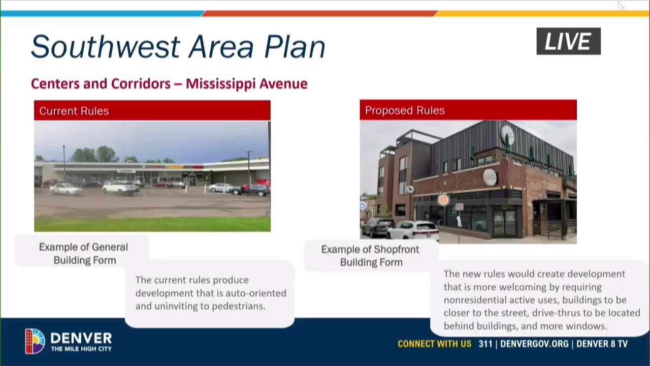
Along Federal Boulevard, staff said during the hearing the proposal would convert old-code parcels into current mixed-use zoning, add the active-centers-and-corridors design overlay near planned bus rapid transit stops, and allow up to five stories south of Mississippi Avenue while keeping lower heights through Little Saigon. On Mississippi Avenue, staff said the main change is adding that same overlay to require more active ground-floor uses and a more pedestrian-oriented form.
On Broadway, staff said the city would rezone a mix of old-code, mixed-use and some industrial parcels so the corridor within the plan area reads more consistently as Main Street zoning, with most of the corridor at three stories and taller zoning retained at key intersections. Around Evans Station, staff said the proposal would shift mostly industrial parcels to urban-center mixed-use zoning ranging from three to eight stories to support transit-oriented redevelopment near the light-rail station.
Morrison Road would get a narrower cleanup. Staff said a handful of former Chapter 59 parcels would be rezoned to match the existing corridor’s mixed-use pattern while keeping flexibility for the street’s diagonal lots. In the Riverside industrial areas, staff described a mix of changes: some Lipan Street properties would move toward Main Street or row-house zoning as a transition from industry to neighborhood uses over time, while designated value-manufacturing areas would move from industrial mixed-use to light industrial to preserve employment land.
The bill title on the committee agenda underscores how broad the map amendment is, listing dozens of current zoning categories and proposed replacements, from old planned unit developments and old-code business districts to new districts including S-MU-3, E-MS-5, C-MS-12, I-A, I-MX-5 and CMP-H2, according to the posted agenda and minutes.
The package also includes scattered housing-opportunity sites. Staff told the committee that about 16 properties owned by Habitat for Humanity or the Denver Housing Authority would move from single-unit to two-unit zoning, while four Denver Housing Authority sites would be rezoned to allow more mixed-use or multi-unit housing. Two institutional sites are also in the bill: the Denver Health Westwood Family Health Center would move from old hospital zoning to campus health-care zoning, and the Westwood library and community center site would move into a mixed-use district that staff said could allow future additions such as affordable housing or expanded services.
A key issue in committee was how some new districts would interact with existing uses. Councilmember Amanda Sawyer asked whether shifting some parcels from industrial mixed-use to residential or light-industrial zoning would create nonconforming properties. Staff said it would, especially in the Lipan transition areas, and said those uses could continue unless they were significantly altered or left vacant for 12 months.
That matters for existing businesses and landowners in the Riverside area because nonconforming-use status can allow a use to continue while making future expansion or reuse harder. Staff said during the hearing the city had heard from Lipan-area business owners worried about those consequences.
Committee discussion also indicated the map could still change before the full council vote. Councilmember Flor Alvidrez said sponsors were “talking about potentially not rezoning” some industrial areas before the bill reaches the floor and that “there could be a floor amendment,” according to the committee video. Staff also said some parcels proposed to move from industrial mixed-use to light industrial might be pulled after the city learned they have existing residential uses.
Another implementation issue was food trucks. Staff told council members the current zoning code allows food trucks in urban-edge districts but not in urban districts, which shaped some proposed map choices. Staff said one property, Table Public House at 2190 S. Platte River Drive, was added at Planning Board for a small zoning change so its existing food trucks could remain allowed.
Members also focused on Federal Boulevard’s parkway setback rules. Council President Amanda Sandoval said the 20-foot setback can clash with the active-frontage, transit-oriented form the city says it wants on Federal, especially with bus rapid transit planned for the corridor. Staff said that issue may need more work with Denver Parks and Recreation.
The rezoning matters because the city has already adopted the Southwest Area Plan, and Denver’s planning department says this map amendment is the next implementation step for corridors including Federal Boulevard, Broadway, the Evans Station area and Morrison Road, as well as industrial and flex areas along Lipan. If the full council approves the map, it would shape future redevelopment decisions across a large swath of southwest Denver, including where apartments and mixed-use projects can rise, where industrial land is protected, and what street-facing design standards new development must meet.
What remains unsettled is the final parcel list for any industrial-area changes before first reading, and which existing properties beyond those discussed publicly may end up operating as legal nonconforming uses under the new map.